Our Goatfell Hike
We set our alarms for 4am and parked up a single track road that opens into a small car park just off the main road in Corriburn Bridge, taking the alternative arran coastal way path that incorporates this peak.
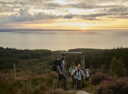
The path is well sign posted as you start to snake up through forests, after 30 minutes or so you start to ascend very quickly, leaving the tree line behind. This is one of those walks where you can’t see the top from the beginning and even at this point the peak is not yet in sight. The sun started to rise over the water of the firth, filling the sky with the most gorgeous orange light and warming us up (we had to stop several times to de-layer and de-head torch!)
The path starts to get steep, and is pretty relentless, the corrie burn spring is to your left but the path is really well marked and easy to get your footing. At 400 metres you meet another path that crosses a ford, this is our return path, for now though we stay straight. By now the peak has stopped being shy and you get to see the whole mountain range of Goatfell has opened up in front of you. Seeing the sunrise light wash over the landscape was pretty special, your path is visible all the way to the top at this point.
As we came to the foot of the big steep climb in Coire Lan we were incredibly lucky to spot a red deer high up on the fell, it was taunting us. We sent the drone up to take a look and what we saw through the screen was incredible….on the other side of the ridge was a huge cloud inversion, thick fluffy white cloud still snuggled at the heart of the island. It gave us a huge push to get to the top as soon as possible so we could see it for ourselves.
There is a last short sharp push where you climb from 600m to 800m very rapidly, but the path is easy to follow and we were rewarded with the amazing cloud inversion at the top. All that heat we had generated was lost at the top as a bracing breeze was there to greet us (layers were swiftly put back on).
At the top you’re turning left to walk along the Goatfell ridge line, there are some tricky spots and you need to be prepared to clamber over rocks. Ensure you have good footwear and a pair of poles if you’re not completely confident on your feet. The views either side of the ridge line were just incredible. You could see all the way across the island.
Although there was only 74m height and not a huge amount of distance to get to Goatfell it takes a little time due to the scrambling, and up & downness of traversing the ridge line.At the peak of Goatfell is a wider flat area with a stone to mark the top. The stone has a beautifully detailed map of the island which is engraved onto a metal plaque. There we took shelter behind some rocks (the wind had really picked up at this point) and ate our lunch.
To head back down you take the ‘tourist route’ off the south east side of the peak, it’s another steep and sharp descent down which is a mixture of steps and scrambling. It’s a popular way up so we saw lots of keen hikers as we decended. At around 600m the path splits into two, the tourist track curving off to the right and down to Brodrick, our path stays straight and head down Meall Breac.
You end up back crossing the ford over Corrie Burn spring and re-joining your start path for the last 30 minutes before you reach the car park.
You can learn more about the route via our Kamoot page, scan the QR code at the top of the page of click on the link here to download the GPX route.

